Heritage Overview
Heritage Overview: Kit Hill in Context
Kit Hill forms part of the Cornubian granite batholith, a geological structure that underpins much of Cornwall’s historic mineral wealth. The hill’s granite composition influenced both its physical form and its long-term exploitation for tin, copper, arsenic, and wolfram.
Archaeological and historical evidence indicates that Kit Hill has been a place of significance for thousands of years. Prehistoric burial mounds and landscape features suggest early ceremonial or territorial use, while later phases reflect agricultural boundaries and resource extraction.
From the eighteenth century onward, Kit Hill became an important industrial site. Mining activity intensified during the Industrial Revolution, leaving behind shafts, spoil heaps, leats, and trackways that remain visible in the landscape today. The nineteenth-century chimney stack at South Kit Hill Mine is now a defining landmark.
At the summit stands an eighteenth-century folly associated with Sir John Call, which is recognised as a Scheduled Monument. This structure reflects both aesthetic and symbolic uses of the landscape during the late Georgian period.
The heritage value of Kit Hill lies not in a single phase of use, but in the accumulation of activity over time. This project approaches the site as a layered landscape, where natural processes and human intervention are deeply intertwined.
The Folly's Journey
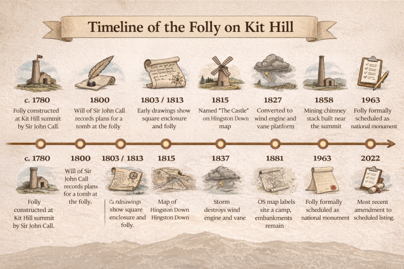
Timeline of the Folly on Kit Hill (1780–2022). Infographic created by Danielle Dowling with the assistance of OpenAI’s ChatGPT image generation (DALL-E).
1780 – Folly Constructed
Sir John Call constructs the ornamental folly at the summit of Kit Hill.
Source: Historic England, List Entry 1004446.
1800 – Sir John Call’s Will
Call’s will records plans for a tomb at the folly, highlighting the site’s symbolic importance.
Source: Historic England, List Entry 1004446.
1803 / 1813 – Topographical Drawings
Early Ordnance Survey topographical drawings show the folly’s square enclosure.
Source: Historic England, List Entry 1004446.
1815 – Hingston Down Map
The folly is labelled “The Castle” on a regional map, indicating local recognition of the site.
Source: Historic England, List Entry 1004446.
1827 – Wind Engine and Vane
Parts of the folly’s north-west bastion are reused for a wind engine and wind vane platform.
Source: Historic England, List Entry 1004446.
1837 – Storm Damage
Storms destroy the wind engine and vane, leaving the earthworks largely intact.
Source: Historic England, List Entry 1004446.
1858 – Mining Chimney Built
Detached chimney for Kit Hill Great Consols mine constructed near the summit.
Source: Historic England, List Entry 1004446.
1881 – OS Map Depiction
The folly is shown as a camp with surviving embankments on the first large-scale Ordnance Survey map.
Source: Historic England, List Entry 1004446.
1907 – Buildings Gone
Most associated mining and landscape buildings are no longer present by this map edition.
Source: Historic England, List Entry 1004446.
1963 – Scheduled Monument
The folly is formally scheduled as a national heritage monument (List Entry 1004446).
Source: Historic England, List Entry 1004446.
1982 – Land Donation
Land including the folly is donated by the Duke of Cornwall to Cornwall County Council.
Source: Historic England, List Entry 1004446.
1988–1989 – Restoration
Turfing and consolidation of the folly earthworks undertaken to protect the site.
Source: Historic England, List Entry 1004446.
2022 – Listing Amendment
The scheduled monument listing is amended to reflect updated protection and information.
Source: Historic England, List Entry 1004446.
Burial Mounds and Barrows
Illustrations of prehistoric burial mounds on Kit Hill: top – Neolithic long barrow with central stone chamber (c. 3000 BC); bottom left – Bronze Age round barrow with stone cist and burial (c. 2000–1500 BC); bottom right – landscape view showing a cluster of barrows on Kit Hill with distant mining chimney.
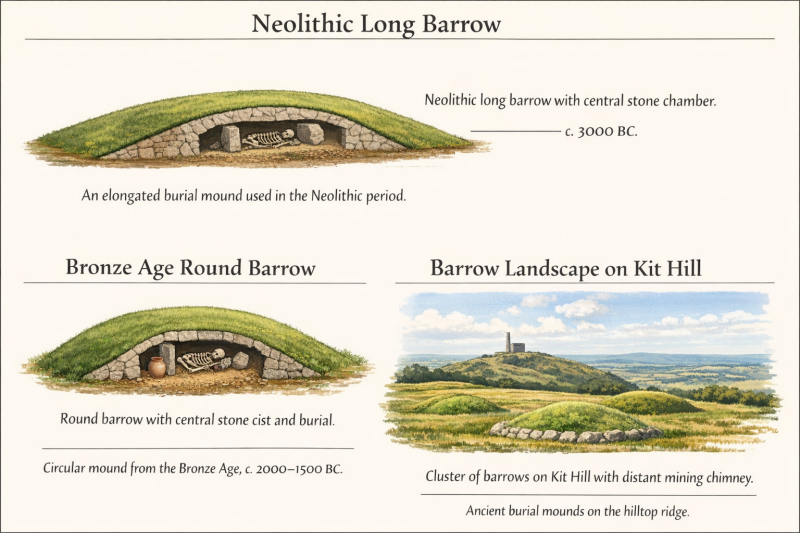
Dowling, D. (2026) Illustrations of Kit Hill prehistoric burial mounds. AI-assisted graphic. (Accessed: 19 January 2026).
Kit Hill Heritage – Burial Mounds and Barrows
Kit Hill’s heritage extends far beyond its industrial and post-medieval history. The hill and its slopes contain a series of prehistoric burial mounds and barrow remains, reflecting human activity in this landscape during the Neolithic and Bronze Age periods (c.3000–1500 BC).
According to Cornwall Council’s interpretation of historic landscape features, at least 18 burial mounds occur on and around Kit Hill, including a Neolithic long barrow on the lower eastern slope and numerous Bronze Age round barrows, which form part of a wider barrow line along Hingston Down.
These burial mounds are significant because they represent some of the earliest known ritual and funerary activity in the region. In prehistoric Britain, barrows and burial mounds were often constructed on prominent hilltops or ridges so that they dominated the surrounding landscape, asserting ancestral or ceremonial significance over the area.
Archaeological surveys and Historic Environment Records identify multiple Bronze Age barrow sites on and around Kit Hill. For example, surveys note several round barrows of varying diameters and states of preservation, forming part of a linear barrow cemetery associated with the ridge linking Kit Hill and Hingston Down. These mounds are often up to 20–25 m in diameter and can be up to 2 m high, although many have been partially levelled or disturbed by later activities.
Although none of the barrow sites on Kit Hill are individually scheduled as separate monuments in the same way as other barrow cemeteries elsewhere in England, their presence is recorded within diverse archaeological evidence and recognised as contributing to the long-term significance of Kit Hill as a multi-period heritage landscape.
The coexistence of these prehistoric funerary features with later historic features — such as mining remains and Sir John Call’s eighteenth-century folly — makes Kit Hill a particularly rich example of how different eras of human activity are layered into a single landscape.
Key Facts
• Prehistoric funerary activity on Kit Hill dates to the Neolithic and Bronze Age (c.3000–1500 BC).
• At least 18 burial mounds are recorded on the slopes of Kit Hill.
• These include a Neolithic long barrow and several Bronze Age round barrows.
• Barrows are earth or stone mounds constructed to cover one or more burials, often with ceremonial or landscape significance.
• Barrow remains form part of a broader prehistoric funerary landscape that extends along the Hingston Down ridge.
The quarrying activity at Kit Hill
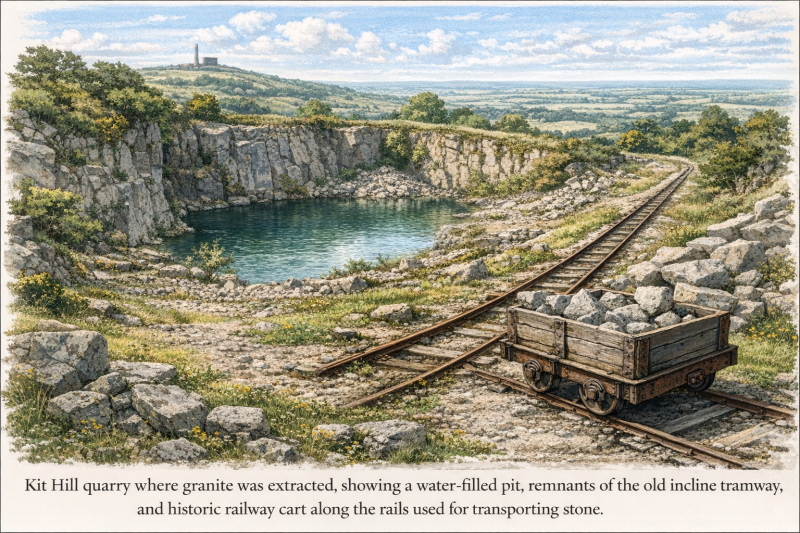
Dowling, D. (2026) Illustration of Quarry with railway heritage. AI assisted graphics
Kit Hill Quarry – Granite and Industrial Extraction
Kit Hill’s quarrying history is an important part of its industrial heritage, reflecting the region’s long tradition of extracting high‑quality granite for local and national use. The quarry sits on the northern slopes of Kit Hill, where granite was worked on a significant scale from the late nineteenth century.
Granite Extraction and Uses
The quarry at Kit Hill was known for producing high‑quality granite, a hard, durable biotite granite associated with the larger Cornish and Hingston Down granite formations. This stone was not only used locally but was also transported considerable distances for engineering and architectural purposes. Examples cited in historical accounts include stone supplied for sea defences, bridges, and embankments in London, such as the Battersea Bridge and sections of the Thames Embankment.
Large blocks and finished stone were often shaped at the quarry before being transported. An incline tramway was constructed from the quarry down the hill, linking with the East Cornwall Mineral Railway (opened in 1872), which facilitated movement of stone to Calstock Quay for shipping, and later to the wider rail network after 1908.
Industrial and Railway Connections
Quarrying at Kit Hill was part of a broader industrial landscape that included mining operations and rail links. The East Cornwall Mineral Railway and later passenger lines provided crucial access for moving both granite and mineral ores. The incline likely followed routes down the slopes to connect with transport infrastructure.
Scale and Appearance
Kit Hill Quarry reached substantial depths, with working faces following natural granite cleavage and showing evidence of early industrial techniques, including manual splitting and later drilling for explosive charges. A detailed survey in the 1980s indicated quarry faces reaching depths of several metres and multiple phases of stone removal, reflecting the shift from simple early workings to more organised nineteenth‑century extraction.
Modern Condition and Landscape Integration
Today, the quarry pit has largely filled with water, forming a deep pool that now supports wildlife such as dragonflies and songbirds, and has become a peaceful feature on walking routes around Kit Hill. The quarry’s former industrial footprint — spoil heaps, stone faces, and the incline route — remains visible in places, offering insight into the industrial processes that shaped this landscape.
The former workings are part of what visitors encounter while exploring the hill’s trails, alongside mining remains and natural reclamation by vegetation.
“Kit Hill has always been an important site and has been shaped by over 5,000 years of human activity…”
Cornwall Council
“Tin and copper mining began here in the 18th century, and the hill became an important mining site…”
360 Cornwall